 "From the Arctic North, satellites watch the world")
Troms, Norway: High above the Arctic Circle, where, in summer the sun never sets and in winter the long polar night shrouds the country in darkness, lies the quiet and unassuming town of Troms. A working port on the edge of the Norwegian Sea, Troms has a rich history of Arctic hunting and polar exploration. Modern Troms is now a home to a thriving community of space science researchers.
Troms is a relatively small city of only 68,000 people, but its proximity to the North Pole makes it a natural candidate for satellite-based remote sensing research. Scientists from Troms University, the world’s northernmost university, private companies and research institutes has come together to form the Centre for Remote Technology . With an almost unique combination of geography and expertise, Troms is a now a key player on the world stage of satellite science.
At the last week’s TEDxTroms conference, the audience heard from Nina Soleng of Kongsberg Satellite Services (KSAT) about Norway’s satellite observation industry.
“Troms is the space capital of Norway,” said Soleng. “Satellites takes 100 minutes to go round the world once and do it 14 times a day. Each one has to pass over the Pole and this is when stations in Troms and (the far northern island of) Svalbard can speak to them. There are 60 satellite missions making 11,000 passes per month.”
One essential task is the monitoring of the polar ice and seaways. Over the last few years, climate change has caused the Arctic ice to melt, opening up the Northeast Passage, which runs across the top of Russia, and the Northwest Passage which skirts North America. These passages provide new shipping routes from Europe to Asia, reducing shipping times by 40 percent.
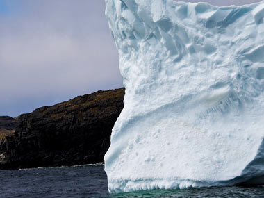
“But an open passage, doesn’t mean that there’s no ice,” says Soleng. “Ice moves 35m per day, and icebergs can be as big as 9 sq km. Conditions change fast. It is very dangerous.”
[caption id=“attachment_72625” align=“alignleft” width=“380” caption=“The ebb and flow of ice makes navigation difficult, which is where remote sensing can help. Natalielucier/Flickr”]
 [/caption]
Not only are maps of the area poor, the ebb and flow of ice makes navigation difficult, which is where remote sensing can help. Satellite images provide real-time, high-resolution data that shows where the ice is at a given area.
“Fresh satellite images provide better navigation,” Soleng says. The satellite data can cut another 20 percent from shipping times.
But satellite imagery doesn’t just look to protect and speed shipping. It can also monitor pollution. As the northern seas open up, so they attract more fishing, leisure cruises, and oil/gas exploration. Care needs to be taken that even small oil spills, for example, are caught early. Satellite monitoring can alert a government within 30 minutes of the image being captured, and can even point a finger at potential perpetrators.
Indeed, August’s oil spill from Royal Dutch Shell’s Gannet Alpha platform in the North Sea was detected from Norway.
Satellite sensing can, of course, cover the globe not just the north. Monitoring the deforestation of tropical rainforest in Brazil, for example, has had a major impact in reducing it, Soleng explains. Satellite imagery and cloud-penetrating radar allowed the government to see exactly where illegal logging and deforestation is taking place. That battle is, of course, far from over .
The continued development of satellite technology means that we’re only going to continue to gather more and more-detailed data. Twenty years ago, a satellite weighed 2 tons and had a resolution on the ground of 2.5m. Now they weigh 10kg and have ten times better resolution, Soleng says.
The CubeSat is a miniaturised satellite about the size of a grapefruit that is built using off-the-shelf components. Chipsats , currently being developed, will be less than a centimetre in diameter and weigh just a few grams. It will be possible to launch them in swarms or glued to the outside of other space craft, providing better coverage, more frequent updates from a larger range of more sophisticated sensors. Gravity, CO2, methane, ice and algae can all be measured, providing an increasingly accurate picture of what’s happening around the Earth.
Back above the Arctic Circle, Troms’s KSAT has been charged with a new mission: Providing the remote data for BarentsWatch . Aiming to provide “coherent picture of what may be happening at any time in the very extensive sea areas in the North”, BarentsWatch will monitor not just for accidents or illegal activities, but also provide essential climate data.
Given the global implications of climate change and the important role of Arctic ice in both climate and sea-level change, it’s fitting that much of our knowledge about it will come from an Arctic space centre.