
 "Google Maps for ancient Rome: Digital archaeology brings 2,000-year-old highways back to life")
With historical records and satellite imagery, researchers have prepared a ‘Google Maps’ of the Roman Empire.
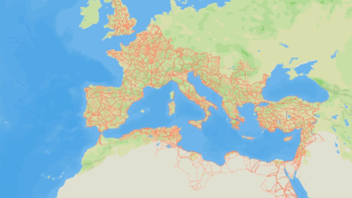
A team of researchers led by Pau de Soto, Adam Pazout, and Tom Brughmans has mapped around 300,000 kilometres of Roman roads, including 110,000 kilometers of newly discovered roads, at the time the empire was at its peak at around 150 AD.
The high-resolution map of the Roman Empire’s road network has been uploaded at itiner-e (https://itiner-e.org/) where one may zoom at the vast road network extending from the British Isles to the Arabian Peninsula. You can also see these roads side by side to current roads and realise that many roads currently in use are nearly as same as build by Romans nearly 2,000 years ago.
“It’s a growing resource for a community to keep on adding information to ensure that this remains the best representation of our knowledge of where all the roads in the Roman Empire were,” Brughmans, an archaeologist at Aarhus University in Denmark, told Nature.
Brughmans said he hopes the data set will “revolutionize our understanding of how people, ideas and infectious diseases” spread 2,000 years ago.
“Such insights can be used to better understand the challenges we face today,” Brughmans further said.
Research fills key vacuum in Roman history
Roads are one of the best-known aspects of Roman history — so much so that ‘all roads leads to Rome’ has today become a popular metaphor.
But it’s surprising how many details about them we still don’t know, Catherine Fletcher, a historian at Manchester Metropolitan University, told Nature.
The research and the database uploaded on itiner-e fills this critical vacuum.
The researchers first identified Roman roads from previous studies, including atlases, surveys, historical sources, archaeological sources, and existing milestones, and then they compared this information to modern and historical aerial photographs, topographical maps, and satellite imagery, the Nature reported.
Impact Shorts
More ShortsThen, they digitised each road section with high spatial resolution and prepared the map for itiner-e.
“This resource is transformative for understanding how mobility shaped connectivity, administration, and even disease transmission in the ancient world, and for studies of the millennia-long development of terrestrial mobility in the region,” the researchers said in their paper in Nature.
At its peak, the Roman Empire stretched from England to Syria and Turkey and covered Northern Africa, such as today’s Egypt, Libya, Tunisia, Algeria, and Morocco.

 "‘We didn’t kill Pakistani citizens’: Rajnath on how India carried Operation Sindoor")
 "Is Pakistan’s 27th Amendment to Constitution the end of civilian rule?")
 "Indonesia: Over 50 injured in explosion at mosque inside Jakarta school during friday prayers")
 "What can Elon Musk do with $1 trillion? He can eliminate world hunger, or buy 2,000 superyachts")


