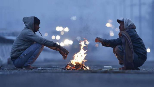
It was a year filled with extreme weather events, from very wet - cold in January to hot spring, summers carried brutal heatwaves to a prolonged monsoon and finally 2022 came to an end with much awaited fresh snowfall over the western Himalayas - as they were experiencing dry weather for months now. The western disturbance paints Himalayas white with a very decent snowfall in parts of Kashmir, Ladakh, Himachal Pradesh and some parts of Uttarakhand during 29 and 30 December, the peaks are filled with snow for the tourists and travelers to enjoy the best time of the year. Accumulated precipitation over the stations of Himalayas in the span of 24 hours ending on 30 December: Snowfall: Zojila: 60.0cm Sonamarg: 45.0cm Kupwara: 20.0cm Gulmarg: 16.5cm QaziGund: 15.0cm Drass: 15.0cm Kothi: 15.0cm Pahalgam: 10.3cm Padum: 8.0cm Kargil: 7.0cm Khadrala: 5.0cm Kukernag: 5.0cm Udaipur: 5.0cm Kalpa: 4.6cm Sangla: 3.9cm Srinagar: 3.0cm Kukumsheri: 3.0cm Shillaroo: 3.0cm Gondhla: 3.0cm Keylong: 2.0cm Rainfall: Saloni: 25.0mm Kasol: 16.0mm Chamba: 14.5mm Manali: 14.0mm Bharmour: 12.3mm Wangtoo: 11.8mm Dharamshala: 11.4mm Ghamroor: 10.0mm Rampur: 9.0mm Dalhousie: 9.0mm Jogindernagar: 9.0mm Once the weather system moved away clear weather is back over the Himalayas leading to major fall in the night temperatures. Recorded minimum temperatures at the major hill stations on the very first day of 2023: Drass: 25.4°c Padum: 23.1°c Kargil: 15.0°c Leh: 14.8°c Keylong: 9.6°c Pahalgam: 9.4°c Gulmarg: 8.2°c Kalpa: 3.5°c Manali: 1.4°c Srinagar: 0.5°c Solan: 1.6°c Mukteshwar: 1.8°c Shimla: 3.1°c Towards the end of the week cold wave abated from most parts of the north India due to the cloudy weather under the influence of the western disturbance which lead to rise in minimum temperatures to double digits across the region, after a harsh cold weather on Christmas, residents in north India celebrated new year eve on a relatively pleasant note. Instead the new year began on a ground shaking note for Haryana and Delhi NCR, an earthquake jolts the region around the mid-night hours at 1:19 am on 1st January, 2023, as per the national center of seismology the magnitude of the quake is measured as 3.8 on the richter scale with a depth of 5km the epicenter was in beri region of Jhajjar, Haryana. As the western disturbance moved away the cold northerly winds from the western Himalayas are moving into the plains, Delhi recorded the minimum temperature of 5.5°c on 1st January fallen from 10.2°c on the 31st December. Temperatures see a dipping trend of 3-4°c across the North India on Sunday morning and cold wave is all set to make a comeback with the beginning of 2023. [caption id=“attachment_11911482” align=“alignnone” width=“546”]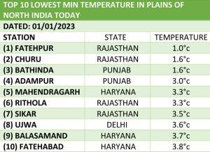 Top 10 coldest stations in the plains of north India on 1st January, 2023, Fatehpur with 1.0c recorded the lowest temperature.[/caption] The cold winds from the north are now knocking doors of central and east India and soon will be extending to the parts of the Southern Peninsula in the upcoming week. On Sunday morning Mumbai recorded a minimum temperature of 15.6°c fallen by nearly 3° compared to 18.0°c on Saturday, Pune recorded 12.5°c, Ahmedabad 13.0°c, Bhopal 10.6°c, 16.2°c, Ranchi 10.4°c, Kolkata 15.5°c on the first morning of 2023. While most parts of Delhi NCR, Haryana and Rajasthan experienced fog free morning, Dense fog enveloped most parts of Uttar Pradesh, Punjab, Chandigarh and Bihar on 1st January as Amritsar, Ludhiana, Patiala, Chandigarh, Meerut recorded NIL visibility at 8:30AM on 1st January while Lucknow, Kanpur, Gorakhpur, Jhansi, Patna observed surface visibility up to 200 meters. [caption id=“attachment_11911542” align=“alignnone” width=“381”]
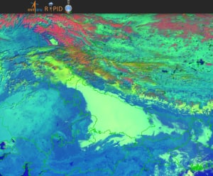 Satellite visulas shows coverage of dense fog in Uttar Pradesh, foothills of Punjab, Haryana on Sunday morning[/caption] Much of the southern peninsula experienced very dry weather on the new year’s Eve as the wet spells from the north east monsoon came to end last mid-week. Most parts of Kerala, Tamil Nadu, Andhra Pradesh, Telangana, Karnataka, Goa start off the new year with dry and pleasant weather, though some wintery feel is on the way in the upcoming week once the continental winds take over. The season of North East Monsoon ends statistically on 31st December, the season brought normal rains for Tamil Nadu, Kerala and Andhra Pradesh, they are the most dependent states on the rainfall during the October to December period. • Tamil Nadu recorded 445.7mm rainfall against the normal of 443.3mm, departure from normal stands at +1%. • Kerala recorded 476.0mm against the normal of 491.9mm, departure from normal stands at -3%. • Andhra Pradesh recorded 341.7mm against the normal of 341.7mm against the normal of 322.9mm, +6% departure from normal. Note that the departure of -19% to +19% is considered as normal rainfall as per Indian Meteorological Department terminology. Subdivision wise seasonal rainfall figures at the end of the season till 31st December: • Southern Peninsula: Actual 298.1mm against the average of 274.1mm, +9% departure from normal. • East & North East India: Actual 176.5mm against the average of 158.9mm, +11% departure from normal. • North West India: Actual 82.8mm against the average of 52.6mm, +57% departure from normal. • Central India: Actual 94.8mm against the average of 76.1mm, +25% departure from normal. [caption id=“attachment_11911552” align=“alignnone” width=“374”]
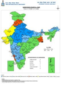 Subdivision wise seasonal rainfall in the period of October till December in meteorological subdivision in India[/caption] Indian Meteorological Department’s predictions for the January to March, 2023: • During the upcoming winter season (January to March 2023) the rainfall over the Northwest India consisting of seven meteorological subdivisions (East Uttar Pradesh, West Uttar Pradesh, Uttarakhand, Haryana, Punjab, Himachal Pradesh, Jammu & Kashmir and Ladakh) is most likely to be below normal (<86 % of Long Period Average (LPA)). • Monthly rainfall for January 2023 over the Northwest India consisting of seven meteorological subdivisions (East Uttar Pradesh, West Uttar Pradesh, Uttarakhand, Haryana, Punjab, Himachal Pradesh, Jammu & Kashmir and Ladakh) is most likely to be below normal (<78 % of Long Period Average (LPA)). Monthly rainfall over the country as a whole during January 2023 is most likely to be below normal (< 82 % of Long Period Average (LPA)). Below-normal rainfall is most likely over most parts of the country except many parts of south peninsular India and some pockets of central India where above normal to normal rainfall is likely. • During January 2023, monthly minimum temperatures are most likely to be below-normal over many parts of central India and adjoining areas of peninsular, east and northwest India. Above normal to normal minimum temperatures are most likely over southern parts of south Peninsula, many parts of northeast India and some parts of northwest India. • Monthly maximum temperatures for January 2023 are likely to be below normal over many parts of central and peninsular India. Above normal maximum temperatures are likely over most parts of northeast India and some parts of northwest, east and east central India. [caption id=“attachment_11911612” align=“alignnone” width=“435”]
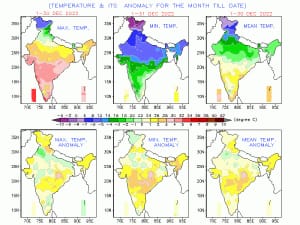 Temperature anomaly in the India during the month of December 2022, above normal temperatures was observed except some parts of North India[/caption] All India weather forecast till 7th January, 2023: The first week of January, 2023 will start with coldwave to severe coldwave conditions across the states of western Himalayas and plains of north India. Dry weather conditions are anticipated across most parts of the country this week as no western disturbance will impact the northern region for another 6-7 days, as the North East Monsoon starts to withdraw from the southern peninsula. Very cold winds from the snow-clad Himalayas are expected to blow across the country which will lead to major fall in night and day temperatures till 7 January. Minimum temperatures can dip as low as -25 to -30°c in parts of Leh, Ladakh and Subzero across Kashmir, Himachal Pradesh and parts of Uttarakhand leading to cold wave conditions at most hill stations, though the sky conditions will remain mainly clear in the upcoming week in absence of any major western disturbance. Cold northerly will ensure fall in night temperatures across Punjab, Haryana, Delhi NCR, Uttar Pradesh, cold wave conditions to set in the region during 2 to 7 January as minimum temperatures are expected to fall as low as 0 to minus 2°c in parts of Punjab, Haryana and Rajasthan whereas Delhi and Uttar Pradesh to experience minimum temperature in the range of 0 to 4°c. Possibility of ground frost is very high along with the dense fog to impact the region in the late night to morning hours. Under the influence of the cold winds, parts of Bihar, Jharkhand, West Bengal, states in the North East India, Odisha, Chhattisgarh, Madhya Pradesh, Maharashtra, Gujarat to experience season’s lowest temperatures in the next 6 days with minimum temperature dipping below 10°c in majority of the stations and may settle below 5°c in parts of Bihar, Madhya Pradesh and Jharkhand, region may reel under cold wave conditions this week. New year starts on a very dry note for most parts of South India as well, mainly clear weather is expected in Karnataka, Goa, Telangana, Andhra Pradesh, Tamil Nadu and Kerala until 7th January. Meanwhile due the presence of dry continental winds - some wintery feel is set in the region during this week at least in the night hours as minimum temperatures might fall below 15°c in some parts of Telangana, Andhra Pradesh and Karnataka whereas below 20°c in some parts of Tamil Nadu. Despite cool nights, days to stay warm with highs mainly above 25°c. Expected range of minimum and maximum temperature in the states of India where coldwave is likely till 7th January, 2022: • Punjab: -2 to 4°c, 10 to 16°c. • Haryana: -1 to 5°c, 12 to 17°c. • Delhi NCR: 1 to 6°c, 14 to 20°c. • Uttar Pradesh: 2 to 7°c, 12 to 16°c. • Rajasthan: -2 to 5°c, 15 to 24°c. • Chhattisgarh: 5 to 11°c, 20 to 25°c. • Bihar: 3 to 9°c, 14 to 20°c. • Jharkhand: 4 to 10°c, 21 to 26°c. • West Bengal: 7 to 14°c, 22 to 29°c. • Odisha: 6 to 13°c, 22 to 30°c. • Madhya Pradesh: 2 to 7°c, 21 to 26°c. • Gujarat: 7 to 15°c, 23 to 29°c. • Maharashtra: 7 to 16°c, 24 to 32°c. • North East India: 2 to 12°c, 18 to 27°c. The author, better known as the Rohtak Weatherman, interprets and explains complex weather patterns. His impact-based forecasts @navdeepdahiya55 are very popular in north India. Read all the Latest News
, Trending News
,
Cricket News
, Bollywood News
, India News
and Entertainment News
here. Follow us on
Facebook
,
Twitter
and
Instagram
.
Temperature anomaly in the India during the month of December 2022, above normal temperatures was observed except some parts of North India[/caption] All India weather forecast till 7th January, 2023: The first week of January, 2023 will start with coldwave to severe coldwave conditions across the states of western Himalayas and plains of north India. Dry weather conditions are anticipated across most parts of the country this week as no western disturbance will impact the northern region for another 6-7 days, as the North East Monsoon starts to withdraw from the southern peninsula. Very cold winds from the snow-clad Himalayas are expected to blow across the country which will lead to major fall in night and day temperatures till 7 January. Minimum temperatures can dip as low as -25 to -30°c in parts of Leh, Ladakh and Subzero across Kashmir, Himachal Pradesh and parts of Uttarakhand leading to cold wave conditions at most hill stations, though the sky conditions will remain mainly clear in the upcoming week in absence of any major western disturbance. Cold northerly will ensure fall in night temperatures across Punjab, Haryana, Delhi NCR, Uttar Pradesh, cold wave conditions to set in the region during 2 to 7 January as minimum temperatures are expected to fall as low as 0 to minus 2°c in parts of Punjab, Haryana and Rajasthan whereas Delhi and Uttar Pradesh to experience minimum temperature in the range of 0 to 4°c. Possibility of ground frost is very high along with the dense fog to impact the region in the late night to morning hours. Under the influence of the cold winds, parts of Bihar, Jharkhand, West Bengal, states in the North East India, Odisha, Chhattisgarh, Madhya Pradesh, Maharashtra, Gujarat to experience season’s lowest temperatures in the next 6 days with minimum temperature dipping below 10°c in majority of the stations and may settle below 5°c in parts of Bihar, Madhya Pradesh and Jharkhand, region may reel under cold wave conditions this week. New year starts on a very dry note for most parts of South India as well, mainly clear weather is expected in Karnataka, Goa, Telangana, Andhra Pradesh, Tamil Nadu and Kerala until 7th January. Meanwhile due the presence of dry continental winds - some wintery feel is set in the region during this week at least in the night hours as minimum temperatures might fall below 15°c in some parts of Telangana, Andhra Pradesh and Karnataka whereas below 20°c in some parts of Tamil Nadu. Despite cool nights, days to stay warm with highs mainly above 25°c. Expected range of minimum and maximum temperature in the states of India where coldwave is likely till 7th January, 2022: • Punjab: -2 to 4°c, 10 to 16°c. • Haryana: -1 to 5°c, 12 to 17°c. • Delhi NCR: 1 to 6°c, 14 to 20°c. • Uttar Pradesh: 2 to 7°c, 12 to 16°c. • Rajasthan: -2 to 5°c, 15 to 24°c. • Chhattisgarh: 5 to 11°c, 20 to 25°c. • Bihar: 3 to 9°c, 14 to 20°c. • Jharkhand: 4 to 10°c, 21 to 26°c. • West Bengal: 7 to 14°c, 22 to 29°c. • Odisha: 6 to 13°c, 22 to 30°c. • Madhya Pradesh: 2 to 7°c, 21 to 26°c. • Gujarat: 7 to 15°c, 23 to 29°c. • Maharashtra: 7 to 16°c, 24 to 32°c. • North East India: 2 to 12°c, 18 to 27°c. The author, better known as the Rohtak Weatherman, interprets and explains complex weather patterns. His impact-based forecasts @navdeepdahiya55 are very popular in north India. Read all the Latest News
, Trending News
,
Cricket News
, Bollywood News
, India News
and Entertainment News
here. Follow us on
Facebook
,
Twitter
and
Instagram
.
Weather Report: India witnesses extreme weather event past year, northerlies to ensure cold in early January
Navdeep Dahiya
• January 2, 2023, 12:36:56 IST
As the new year marks the end of an year with extreme weathers, the first week of January, 2023, will start with cold wave to severe cold wave conditions across the states of western Himalayas and plains of north India
Advertisement
 "Weather Report: India witnesses extreme weather event past year, northerlies to ensure cold in early January")
End of Article