
 "Indo-American NISAR satellite set for launch: Huge potential to unlock")
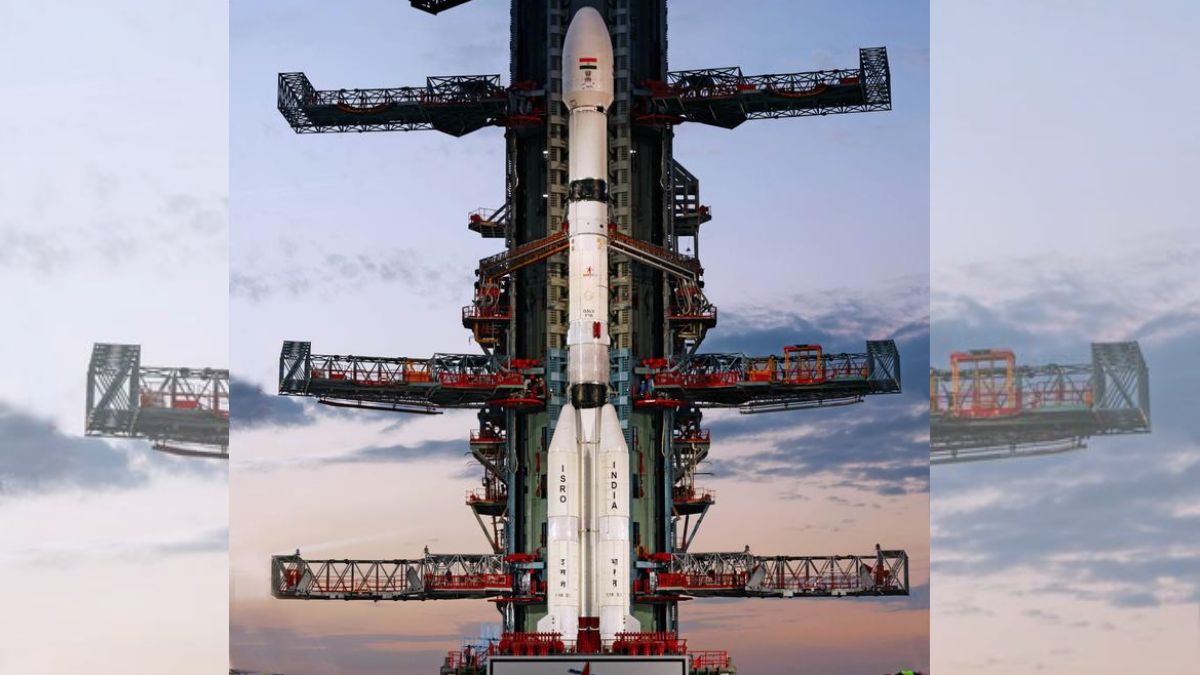
NASA-ISRO Synthetic Aperture Radar (NISAR), the first joint satellite of the Indian Space Research Organisation (ISRO) and the National Aeronautics and Space Administration (NASA), will be launched by ISRO’s GSLV-F16 on July 30 evening from Satish Dhawan Space Centre (SDSC SHAR), Sriharikota. It is a unique earth observation satellite and the first to observe the Earth with a dual-frequency Synthetic Aperture Radar (NASA’s L-band and ISRO’s S-band), both using NASA’s 12m mesh reflector antenna integrated into ISRO’s modified I3K satellite bus.
The satellite will scan the entire globe and provide all-weather, day-and-night data at a 12-day interval, enabling a wide range of applications. NISAR can detect even small changes in the Earth’s surface, such as ground deformation, ice sheet movement, and vegetation dynamics. Further applications include sea ice classification, ship detection, shoreline monitoring, storm characterization, changes in soil moisture, mapping and monitoring of surface water resources, and disaster response.
Earth Observation Satellites
Earth Observation (EO) satellites are broadly classified into optical, radar, and hyperspectral types, based on their sensor technology. These satellites play crucial roles in applications like environmental monitoring, disaster management, and resource management. Optical satellites use cameras and sensors to capture images of the Earth’s surface in the visible and near-infrared spectrums. They are effective for tasks like land cover mapping, agriculture monitoring, and urban planning. India’s IRS series is an example.
Radar satellites use active microwave sensors to penetrate clouds and darkness, providing all-weather, day-and-night imaging capabilities. They are valuable for applications such as monitoring sea ice, mapping terrain, and tracking changes in infrastructure. India’s RISAT series is an example. Hyperspectral satellites capture images across a very wide range of electromagnetic wavelengths, providing detailed spectral information about the Earth’s surface. They are useful for applications like mineral mapping, precision agriculture, and environmental monitoring. An example is ISRO’s HysIS.
Quick Reads
View AllIn addition to sensor type, EO satellites can also be categorized by their orbits. Those in Low Earth Orbit (LEO), relatively close to Earth, provide high-resolution images and detailed observations. Those in Medium Earth Orbit (MEO) offer a balance between coverage and resolution, with longer revisit times than LEOs. Geostationary Orbit (GEO) satellites remain stationary over a specific location on Earth, providing continuous monitoring of a region. Sun-Synchronous Orbit (SSO) satellites orbit the Earth in such a way that they pass over a specific location at the same local time each day, allowing for consistent data collection.
NISAR Satellite Details
The NISAR satellite, weighing 2392 kg, will be injected into a 743 km Sun-synchronous orbit. NISAR will observe the Earth with a swath of 242 km and high spatial resolution, using SweepSAR technology for the first time. The NISAR satellite has a large antenna reflector that is 39 feet (12 meters) in diameter. This reflector is mounted on a 30-foot (9-meter) boom.
NISAR’s main body contains a dual-radar payload, an L-band system with a 10-inch (25-centimeter) wavelength, and an S-band system with a 4-inch (10-centimeter) wavelength. The satellite will be three-axis stabilized and will require 6,500 watts of power to operate. NISAR is among the more expensive satellites at $1.5 billion. ISRO’s share of the project cost is about ₹788 crore (US$93 million), and NASA’s share is about US$1,118 million. By including both radars on one spacecraft—a first—NISAR will be more capable than previous SAR missions.
The two SARs aboard NISAR will detect changes in the planet’s surface down to fractions of an inch, using the radar antenna reflector. The satellite’s ability to “see” through clouds and light rain, day and night, will enable users to continuously monitor areas of interest. Its near-comprehensive coverage will include regions not previously covered by other Earth-observing radar satellites with such frequency. It will also offer unprecedented coverage of Antarctica, providing information that will help study how the continent’s ice sheet changes over time.
The NISAR satellite’s L-band radar penetrates deep into forest canopies, providing insights into forest structure, while the S-band radar is ideal for monitoring crops. NISAR data will help researchers assess how forests, wetlands, agricultural areas, and permafrost change over time. The radars will generate about 80 terabytes of data products per day over the course of NISAR’s prime mission—that’s roughly enough data to fill about 150 512-gigabyte hard drives each day. The information will be processed, stored, and distributed via the cloud and accessible to all.
What Will NISAR Provide?
Each system is sensitive to land and ice features of different sizes and specializes in detecting certain attributes, such as moisture content, surface roughness, and motion. SAR will provide high-resolution data, enabling scientists to comprehensively monitor the planet’s land and ice surfaces like never before. Data from NISAR will map changes to Earth’s surface, helping improve crop management, natural hazard monitoring, and tracking of sea ice and glaciers. Information will help protect and educate communities worldwide on how to manage agricultural fields, monitor volcanoes, and track land-based ice, including glaciers.
NISAR will provide crucial data to decision-makers, communities, and scientists to monitor agricultural fields, refine understanding of natural hazards such as landslides and earthquakes, and help teams prepare for and respond to disasters like hurricanes, floods, and volcanic eruptions. The satellite will also provide key global observations of changes to ice sheets, glaciers, permafrost, forests, and wetlands.
Indo-US Cooperation at Next Level
The first joint satellite mission between NASA and ISRO, NISAR marks a new chapter in the growing collaboration between the two space agencies. Years in the making, the launch of NISAR builds on a strong heritage of successful programs, including Chandrayaan-1 and the recent Axiom Mission 4, which saw ISRO and NASA astronauts living and working together aboard the International Space Station (ISS) for the first time.
The NISAR satellite features components developed on opposite sides of the planet by engineers from ISRO and NASA’s Jet Propulsion Laboratory (JPL) working together. The S-band radar was built at ISRO’s Space Applications Centre in Ahmedabad, while JPL built the L-band radar in Southern California. After engineers from JPL and ISRO integrated NISAR’s instruments with a modified ISRO I3K spacecraft bus and tested the satellite, ISRO transported NISAR to Satish Dhawan Space Centre in May 2025 to prepare it for launch.
The SAR technique was invented in the U.S. in 1952, and now countries worldwide have SAR satellites for a variety of missions. NASA first used the technique with a space-based satellite in 1978 on the ocean-observing Seasat, which included the first space-borne SAR instrument for scientific observations. In 2012, ISRO began launching SAR missions starting with Radar Imaging Satellite (RISAT-1), followed by RISAT-1A in 2022, to support a wide range of applications in India.
Managed by Caltech in Pasadena, JPL leads the U.S. component of the project and provided the L-band SAR. JPL also provided the radar reflector antenna, the deployable boom, a high-rate communication subsystem for science data, GPS receivers, a solid-state recorder, and a payload data subsystem. NASA’s Goddard Space Flight Center manages the Near Space Network, which will receive NISAR’s L-band data.
The ISRO Space Applications Centre is providing the mission’s S-band SAR. The U R Rao Satellite Centre is providing the spacecraft bus. The rocket is from Vikram Sarabhai Space Centre, launch services are through Satish Dhawan Space Centre, and satellite mission operations are by the ISRO Telemetry Tracking and Command Network. The National Remote Sensing Centre is responsible for S-band data reception, operational product generation, and dissemination.
Preparation for Launch
The satellite was originally scheduled to be launched from India aboard a GSLV Mark II on 30 March 2024 but was postponed due to required hardware updates. On 15 October 2024, after the completion of all checks and tests, NASA’s C-130 took off from Wallops Flight Facility in Virginia to embark on the multi-leg, multi-day journey to India. The flight first stopped at March Air Reserve Base to retrieve the spacecraft, followed by strategic stops at Hickam Air Force Base, Hawaii; Andersen Air Force Base, Guam; Clark Air Base, Philippines; and finally reached HAL Airport in Bengaluru, India. By late January 2025, the satellite had finished all preliminary checkout in Bengaluru and was ready to be shipped to SDSC. By May 14, technicians had placed the satellite in a specialized container and transported it about 360 kilometres by truck to SDSC, where it arrived the following day. The NISAR satellite is now mounted on GSLV for launch on July 30. All systems of the launch vehicle have been checked and are “GO” at present.
To Summarise
NISAR will operate at an inclination of 98.5°, and the mission duration is planned for 3 years. The National Centre of Geodesy facilities at IIT-Kanpur and IIT-Patna will host a corner reflector for NISAR. The mission is optimized for studying hazards and global environmental change, specifically in support of its three core science disciplines: Ecosystems, Cryosphere, and Earth Surface and Interior. The satellite is designed to provide a detailed view of the Earth to observe and measure some of the planet’s most complex processes, including ecosystem disturbances, ice-sheet collapse, and natural hazards. As with all NASA missions, NISAR data will be openly available, free of charge. Most areas will be imaged 4–6 times per month.
Planned nominal spatial resolution in most areas is 12 m, but operational modes can support 3–50 m resolution. Although the science requirement is a 30-day maximum latency, the NISAR project’s goal is delivery of Level 1 & 2 products within 24–48 hours of acquisition. Level 1 products include Single Look Complex (SLC), Multi-Look Detected (MLD), and interferometric products, while Level 2 products are geocoded versions of Level 1 data. These products are crucial for various scientific applications, including monitoring earthquakes, glacial movements, and ecosystem changes.
NISAR can address many ecosystem applications, including annual carbon accounting and mapping and characterization of wildlife habitats, wetlands, land use, agriculture, water availability, and wild-land disturbance. A core benefit of spaceborne SAR data is its active remote sensing capability in cloud-covered conditions, independent of solar illumination.
Hydrology and subsurface reservoir applications of NISAR include measuring ground surface subsidence and rebound to within centimetre accuracy, as well as mapping soil moisture, surface water, snow, and deformation associated with water and hydrocarbon withdrawal, wastewater injection, and carbon sequestration. Determining the timing of snow-off conditions is important for agencies to identify the start of the fire season.
Changes in ground surface subsidence over oil, gas, and hydrothermal reservoirs provide estimates of changes in the water table (hydraulic head), location and depth of oil and gas, help manage fracking activities, and resolve the shape and characteristics of hydrothermal reservoirs.
Marine and coastal hazards include mapping and classifying hard targets (e.g., ships and icebergs), shorelines, and storm damage; monitoring marine wind speed, wave spectra, and severe storms; and identifying oil spills. Detection and classification of sea ice, icebergs, and ships is used by ice service agencies to aid navigation, particularly for shipping trade routes, search and rescue, and coastal border patrols. Low-latency data will be very valuable.
Measurements of surface movement associated with earthquakes, volcanoes, landslides, sinkholes, and secondary hazards such as tsunamis generated by earthquakes and landslides will be very helpful.
The benefit of NISAR for critical infrastructure monitoring derives primarily from the 12-day temporal repeat, the near-complete land imaging, and the day/night observation capability. Such information from across the LoC and LAC would be a tactically useful addition. It will be interesting to monitor glacier melting and water flows from across the Himalayas as these are lifelines for India and also have strategic connotations.
ISRO Earth observation missions are highly focused on applications of practical and quantifiable benefit to society, whether it is routine monitoring or rapid response. ISRO’s Utilisation Programme goals are ready with applications for utilisation of the data from the mission with the intent of achieving operational outcomes. Lastly, and most importantly, the mission will give Indian planners, the scientific community, end-users, and other stakeholders a wealth of experience and data.
The writer is former Director General, Centre for Air Power Studies. Views expressed in the above piece are personal and solely those of the author. They do not necessarily reflect Firstpost’s views.

 "Trump finds new raid target? Report says US actively seeking regime change in Cuba by 2026-end")
 "Trump meets Zelenskyy in Davos, says 'a ways to go' on ending Ukraine war")
 "Power shift in Hanoi: Vietnam party list hints PM and president losing clout")
 "Can Trump’s Board of Peace replace the United Nations?")


