
 "Countering China, enabling communities: How India’s Vibrant Village Scheme brings hope to borderlands")
In 1913, Sir Henry McMahon, India’s the foreign secretary, commissioned two intrepid young officers, Capt FM Bailey, an intelligence officer, and Capt HT Morshead, a surveyor, to map the north-eastern border of India.
They eventually produced the first detailed map of what is today Arunachal Pradesh; a year later, their findings were used by McMahon to draw the famous line carrying his name.
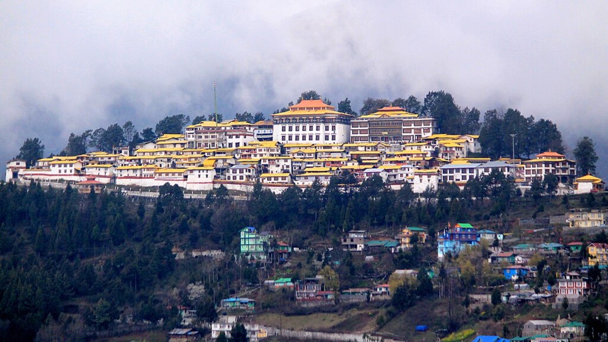
Tawang
An anecdote reported by Morshead after his visit to Mago village and Tawang (then also a village) showed that the local Monpa population had hardly any knowledge of the nearby areas, both today in Tawang district.
It is interesting in the context of the recent developments of tourism in the region.
The surveyor wrote: “In Mago there were no officials … They asked if we knew Tawang.” “Not yet,” we said, “but we are going there.” “What a place!” they answered. “So many houses! So many people! And the chang (barley beer)! There is no chang like the chang you get there. And the girls, who sing and dance for you. You haven’t seen girls till you go to Tawang!” None of them had visited Tawang.
Things have changed today, especially after May 2020, when the Chinese intruded in Ladakh; this has triggered a sea of change on the border on the part of the Indian government and translated into a much closer welcome collaboration between the Indian Army and the civil administration in border areas.
During a recent visit to Mago, Thingbu and Tawang, I have seen the sweeping consequences of these new policies.
Thingbu Village
The village of Thingbu is located some 15 km from Mago at an altitude of 11,000 ft. The population belongs to the Monpa tribe, like in Tawang; the census said that 58 households live in Thingbu.
Impact Shorts
More ShortsThis was on one of the routes used by the Chinese Army to bring reinforcements to Dirang and Bomdila during the second phase of the Sino-Indian War (November 18-20, 1962).
Thingbu is just off the famous ‘Bailey Trail’, the historic route taken by Capts Bailey and Morshead in 1913. After completing the survey along the Great Bend of the Yarlung Tsangpo River, the two Britishers returned into Indian territory at Tulung-la pass, descending to Mago village, then crossing over Tse La pass before proceeding to Dirang and Tawang and finally to Tsona Dzong in Tibet. The first part of their journey from Mago is known as the ‘Bailey Trail’.
Incidentally, a war memorial has been built at Tulung-la, the site of a treacherous Chinese attack on an Assam Rifle detachment in October 1975.
Development
The greatest change in Mago and Thingbu has been the construction of a tar road leading to Jiang and Tawang. The village of Thingbu has always been quite prosperous (it owned about 1,000 yaks); however, it could not communicate with the outside world. Today, the villagers greatly appreciate the Central Government’s Vibrant Village Program and the role of the Indian Army in providing roads, schools, small dispensaries and drinking water. The villagers don’t need to dream of Tawang as the paradise on earth anymore.
Arunachal Pradesh Chief Minister Pema Khandu noted that the joint collaboration between the district administration, the Indian Army and the Indo-Tibet Border Force (ITBP) authorities will help develop the Mago-Chuna region.
Tawang Again
Tawang has always had great strategic importance, as the town is located only 14 km from the Line of Actual Control (LAC), as the crow flies.
Here too the Indian Army and the Civil Administration have initiated multifarious activities with the objectives to develop the area into a modern example of dual-use (military-civilian) for the rest of the northeast as well as to uplift the conditions of the local population, while bringing amenities along the LAC to prevent any new Chinese misadventures.
An example is the opening of tourist circuits (including war tourism) right on the border and the establishment of jointly run institutes.
Operation Sadbhavana, an initiative aimed at fostering goodwill and improving the lives of people in conflict-affected areas, has initiated programmes under several themes which make a difference for the local population: youth empowerment, assistance to schools, medical camps, dual-use infrastructure and promotion of the local culture.
A press release of the local administration explains: “The projects, in addition to meeting the local aspirations while complementing the civil administration efforts, have dual use for the military.”
Major Bob Khathing Museum
One of the most visible recent initiatives is the Maj Bob Khathing Museum, located near Arunachal Pradesh’s largest war memorial, honouring those who fought and died against the Chinese troops in October/November 1962. Maj Khathing was instrumental in bringing Tawang under the Indian administration in February 1951.
The ‘Museum of Valour’, designed to honour the legacy and expedition of Major ‘Bob’ Khathing, is a successful collaboration between the Government of Arunachal Pradesh and the Indian Army.
The museum has different galleries to showcase the kaleidoscopic features of the Tawang district; to name a few: the ‘Soul of India’ gallery aimed towards recognising India’s Unity in Diversity and another gallery displaying several personal belongings of the intrepid soldier (later diplomat).
One should not forget the crucial role played by Jayaramdas Dhaulatram, the then Governor of Assam, who organised the entire military expedition led by Maj Khathing. Some panels are dedicated to the great statesman.
The ‘Monyul Blessed Land of the Monpa’ gallery showcases the history and heritage of the Tawang area and its deep connection with other parts of India.
The entire museum is an extremely educational experience for the general public, often not aware of the history of the border.
The Holy Tree
Khinzemane is a significant post located close to the Line of Actual Control (LAC) on one of the spurs of Thagla Ridge on the Nyamjang Chu (river).
Located on the old trade route between Lhasa and Tawang, the post has always assumed a historic, strategic and religious importance.
It is also the only foothold that the Indian Army has on Thagla Ridge, north of Namka Chu, asserting India’s claim on the ridge, which defines the border as per the watershed principle.
A tree, now known as the Holy Tree, was planted at the Khinzemane post by the 14th Dalai Lama when he took refuge in India on March 31, 1959. The area, which for decades has been a forbidden area, has now been developed to receive Indian visitors and give them glimpses of the history of the border.
The Nyamjang Chu valley and the adjacent ridges saw the first clashes of the 1962 border war with China.
Since the relaxation of the policies for border tourism (mostly after the Ladakh confrontation), the Holy Tree area has become a sought-after destination for tourists from all over India.
It is unfortunate the Indian public has often been the victim of the Chinese narrative about the 1962 border conflict; the recent initiative by the Indian Army and the Arunachal Government should go a long way to make known a true narrative of the conflict.
Zimithang and Gorsam Chorten
Zimithang is the last administrative headquarters of Indian administration before the Tibet border; it is also one of the villages under the Vibrant Village Program. During the 1962 War, it was the Tactical Headquarters of the 4th Mountain Division, who fought north of Tawang.
Nearby the small town of Zimithang is the Gorsam stupa, one of the largest stupas in South Asia, designed on the model of the Bodhnath stupa in Kathmandu. A Gorsam Kora festival is regularly held in Zimithang Valley. During these festivals, thousands of devotees from Tawang, West Kameng, Lumla, Shakti, Bomdila, Dirang and even Bhutan attend the religious event.
Vibrant Village Programme
Most of the villages on the border come under the Ministry of Home Affairs’ Vibrant Village Programme, wherein 2,967 border villages were identified across four northern states and Ladakh.
The Indian Army fully participates in the various initiatives for the overall development of these identified villages. More than 150 villages have been selected in Tawang district alone.
Many more initiatives could be cited, but visiting these places after a few years, one realises how quickly they have finally entered the national consciousness and how much better off tiny villages like Mago or Thingbu or larger towns like Tawang are today.
One can only hope that while the process of development is going on, the environment will continue to be respected.
And I should not forget to mention one of the most exciting yearly events jointly conducted by the Army and the civil administration: the Tawang Marathon; a similar race was organised in Leh.
While Tibetan settlements across the LAC remain under the occupation of a foreign force, India’s border villages in Arunachal are witnessing inclusive development. It will be an advantage in case of a conflict.
The writer is Distinguished Fellow, Centre of Excellence for Himalayan Studies, Shiv Nadar Institution of Eminence (Delhi). Views expressed in the above piece are personal and solely those of the writer. They do not necessarily reflect Firstpost’s views.

 "'You'll not receive any prisoner': Hamas says Netanyahu's Gaza City op ends hope for hostages")
 "Pakistan-China push to label BLA a terror group blocked by US, UK and France at the UN")
 "India vs China: Who has more millionaires?")
 "Why India struck Pakistan’s terror camps after midnight during Op Sindoor")


