
 "A dammed history of the Kosi")
A decade after the catastrophic Kosi embankment breach, a look at the history of embankments in Nepal and northern India By Peter Gill and Bhola Paswan In Kusaha village, news of an impending disaster spread quickly on the morning of 18 August 2008. Kusaha is located in Sunsari District in Nepal’s southern plains, just five kilometres from the Indian border, on the east bank of Nepal’s largest river, the Kosi. In the 1950s, the Indian government built embankments (also known as dikes or levees) along roughly 150 km of the Kosi, in both Indian and Nepali territory, in order to prevent floods. At the time of its construction, the embankment separating Kusaha from the river was roughly five-metres tall and, at its base, was a 50-metre wide wall of compacted earth. But the monsoon-swollen river had eroded the embankment so that it was now just a few meters thick. The water could break through any moment. When Sahadev Yadav, a Kusaha farmer in his 40s, heard the news, he didn’t believe a break was possible. Along with several neighbors, he climbed the embankment to see the damage for himself, and was horrified. “Everyone was saying, “God, God, God,” recalls Samsul Mia, another Kusaha resident. Yadav ran home to warn his family, collect their meagre cash savings and official documents, and move to higher ground. Suleiman Mansuri, a construction contractor in his 30s, was nearby when the waters broke through, around 2 PM. “There was suddenly a lot of mist, like fog had rolled in,” he says, describing the influx of water. Several hectares of land were inundated immediately; soon Kusaha was under a metre-and-a-half of fast-moving water. The break in the embankment continued to spread over the coming 24 hours until it was over a kilometre wide, and the flow grew stronger. Although no one died in Kusaha itself, there was calamity downstream. Over 400 people died and millions were affected by the floods in Bihar, while several dozen people died and tens of thousands were displaced in Nepal. Like the villagers in Kusaha, the Nepali and Indian governments appeared to have been caught off-guard. Just two days before the breach, the Indian Chief Engineer for the Kosi Project, which is part of Bihar’s Water Resources Department and administers the embankments on both sides of the border,
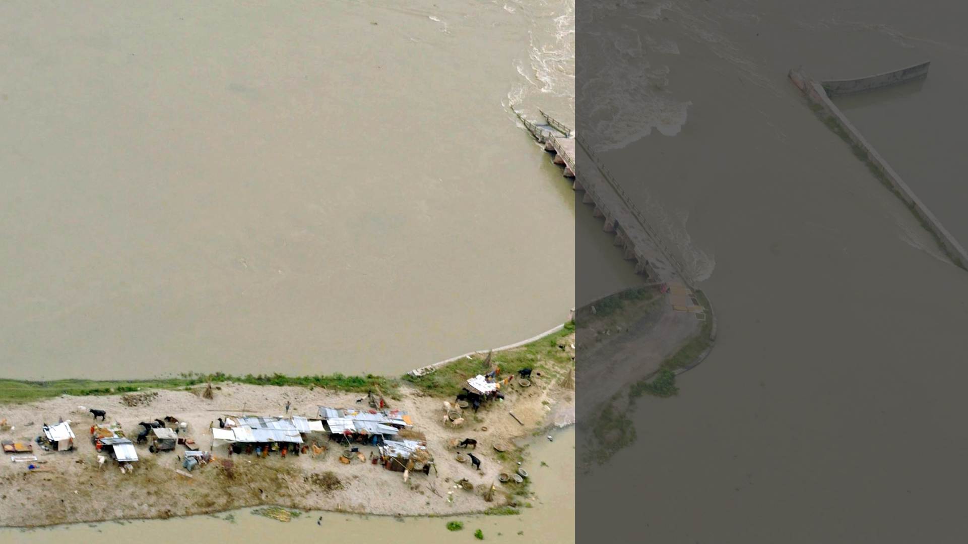
had denied there was any danger. In many cases, victims received no warning about the floods, and bureaucratic hierarchies hindered communication between the two governments. Even the Kosi Treaty of 1954, under which the embankments in Nepal were established and maintained, lacked provisions for what to do in the case of a breach. The people and governments of Nepal and India had simply assumed the structure would not fail. And yet, there was already a long and tragic history of river embankment breaches in both countries. [lq][caption id=“attachment_5224091” align=“alignnone” width=“1024”]
 There was already a long and tragic history of river embankment breaches in both India and Nepal[/caption][/lq] A history of embankments In pre-colonial north India, farmers and zamindars (landlords) sometimes constructed earthen embankments known as bundhs along short stretches of rivers to protect small tracts of land from flooding for certain periods of time. But historical accounts suggest such constructions were intentionally ephemeral, and never aimed to fully eliminate floods. Rather, many farmers depended on occasional river floods to deposit silt and organic matter from upper catchments in their fields, providing nourishment to crops before the age of modern chemical fertilisers. Floods sometimes entered villages and damaged homes, but because the current was usually slow and water was able spread over extensive plains, the damage was often limited. The British built the first large-scale embankments in South Asia aimed at permanently preventing floods. They often contracted with local zamindars or tax collectors, who in turn organised the labour to build extended earthen bundhs for long sections of flood-prone rivers. While official rhetoric emphasised the benefits for poor farmers, the colonial rulers also had certain self-interests in mind. In the Mahanadi delta of Orissa, for example, the historian Rohan D’Souza has argued that the British
attempted to control meandering waterways to delineate property more clearly and strengthen the role of tax-collecting authorities. This helped usher into the world of colonial capitalism what he called a “flood-dependent agrarian regime” The British also built embankments to protect infrastructure. In the 1850s, they undertook perhaps their most ambitious project – the embankment of a section of the Damodar river, west of the colonial capital Calcutta (now Kolkatta), to protect a new railway. But problems soon emerged. Farmers complained that the lack of silt hurt agricultural yields. And embankments prevented water outside of rivers from draining into the rivers, causing and prolonging floods. What’s more, when the embankments broke – which, absent constant maintenance and reinforcement, they inevitably did – they unleashed waters into surrounding territories at high velocities, causing much more damage than slow-rising floods historically had. Because they were so unsuccessful at preventing floods, most of the Damodar embankments
had to be demolished within a decade of their construction. Sediment – from silt to sorrow These problems were exacerbated by a particularly irksome nuisance: sediment. Several major tributaries of the Ganga in northern Bihar, which descend from the eastern Himalaya in Nepal, were particularly notorious for sediment. The largest, the Kosi, has a catchment area of nearly sixty-thousand square kilometres in the Tibetan plateau and Nepali mountains before debouching into the plains. In its upper reaches, the water carries large quantities of earth – “alluvium” – eroded from the mountains and hills. Although the science of calculating river sediment loads is imprecise, modern studies suggest the river carries between
80 million and
120 million cubic meters of sediment per year, or a cubic kilometre every eight to 12 years. Once the river reaches the plains it slows down, and riverine “hitch-hikers” begin to drop out of the water column and settle: first the largest stones, followed by sand, then silt, and progressively smaller particles as the velocity decreases. This deposition leads the river bed to continually rise, and so the river seeks to change course, always looking for lower ground, creating one of the
largest alluvial fans in the world. Between the mid-18th century and the mid-20th century, the Kosi migrated over 100 kilometres westward, abandoning old channels and forming new ones. Along with mercurial water flow – the Kosi’s typical monsoon-season discharge is five to ten times
its dry-season discharge – sediment contributed to flooding. But sediment also complicated British flood-control efforts. When they attempted to build embankments along small sections of the river, the river bed began to rise faster than before because the deposited alluvium had less space to spread out. This resulted in the river becoming super-elevated relative to the surrounding floodplain, making breaches all the more dangerous. [rq][caption id=“attachment_5223881” align=“alignnone” width=“1024”]
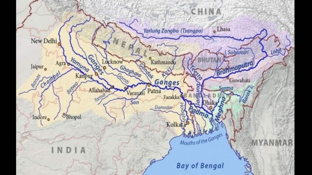 Between the mid-18th century and the mid-20th century, the Kosi migrated over 100 km westward[/caption][/rq] Dinesh Kumar Mishra, a Bihar-based engineer and civil society activist who has conducted extensive historical research on the Kosi, has written that British engineers and other officials began to
rethink flood control efforts by the late 19th century. At a flood conference in Calcutta in 1897, an army officer compared embankments to throwing one’s gloves “in Nature’s face, an insult which she is not yet known to leave un-avenged.” By the late colonial period, engineers in Bihar had all but given up on embankments. Captain GF Hall, the chief engineer of the state, told colleagues in 1937 that he wanted to emphasize “one point and one point only as a preliminary to government devising a flood policy, i.e., that bundhs obstruct the free flow of water and accentuate instead of relieve the intensity of floods.” However, official opposition to embankments did not last long. Post-Independence boost Mishra shows that flood-control policy experienced a quick about-face following Indian independence. Public and media attention initially turned to an idea that had been floated as early as 1937 – to build a high dam that could hold back flood waters at Barahakshetra in Nepal, where the Kosi debouches from the hills. However, an Indian government committee declared the dam infeasible in 1951 (it would have cost INR 1.77 billion – an astronomical sum at the time when the Indian rupee was almost at par with the US dollar – and taken nearly two decades to build). In 1953, devastating floods hit the Kosi and, amid public pressure for the government to act, embankments gained favour once again. After Prime Minister Nehru toured affected areas, his government announced a plan for a “Kosi Scheme” to embank nearly 150 kilometres of the river from near the base of the Himalayas in Nepal to near its confluence with the Ganga in Bihar. The decision to build the embankments was based on what Mishra euphemistically calls “extra-technical” considerations. He notes that the government sent engineers on trips to the Yellow River in China and the Mississippi in the US to assess the feasibility of embanking large rivers. But in fact, the feasibility trips occurred only after the Kosi Scheme had essentially been approved. Foreign counterparts in both the US and China recommended the Indians consider the effects of siltation carefully. The Indian engineers seemed to ignore serious problems on the rivers they visited: both the Mississippi and Yellow had experienced embankment breaches and devastating floods in recent decades. (For example, in 1938, Chiang Kai Shek’s Nationalist Army cut through embankments on the Yellow to induce a flood to halt oncoming Japanese imperial troops,
killing nearly a million people. Though it was intentional, the flood was all the more destructive because of the Yellow’s super-elevation relative to the surrounding land.) [imgcenter]
The problems emerge Despite initial euphoria, problems soon emerged. Because the river could not be pinched too closely, a significant slice of land – roughly 100,000 hectares, including over 300 villages in Bihar – had to be left within the embankments, at the mercy of floods. As construction of the embankments moved ahead, villages lobbied with the government to change the alignment so their villages would be outside. Villages turned against one another; women and children staged satyagrahas, and gangs of men from inside the embankment fought those from outside with sticks. In the long-term, the problems the British engineers had warned about re-surfaced. Although drainage pipes were constructed through embankments so that water outside the embankments could drain in, these usually failed to function well and became completely useless once the river bed became super-elevated. The project had originally been designed to protect over 2,000 square kilometres, but by the 1990s over 3,000 square kilometres had become water-logged. Meanwhile, floods continued. Although river engineering textbooks called for “fire-fighting-type maintenance” to keep embankments safe, in reality they were often neglected by corrupt construction contractors, damaged by burrowing animals, or in some cases cut through by villagers living on the inside of embankments seeking to save their own homes. Although attempts were made to resettle people living within the embankments, over 200,000 continue to live there today. Major breaches of the embankments occurred seven times prior to the 2008 Kusaha breach, in 1963, ‘68, ‘71, ‘80, ‘84, ‘87, and ‘91. Government data showed that the flood-prone area in Bihar gradually increased from 2,500,000 hectares (25,000 square kilometres) in 1954 to 6,800,000 hectares (68,000 square kilometres) in 1994. This is the first in a three part series on the history of embankments in India and Nepal along the Kosi, a major tributary of the Ganga. Read part two here. Peter Gill is an American journalist based in Nepal who writes on the environment, politics, society, and travel. Follow him on Twitter at @pitaarji. Bhola Paswan is a Nepali journalist who writes on a variety of political and social issues for the national dailies Kantipur and Nagarik, among others. Follow him on Twitter at @paswanbhola. The Third Pole is a multilingual platform dedicated to promoting information and discussion about the Himalayan watershed and the rivers that originate there. This report was originally published on thethirdpole.net and has been reproduced here with permission.
 "US ready to ‘impose costs’ on Russia if war in Ukraine drags on, says Hegseth")
 "US tells Hamas to stop violence against Gaza civilians and disarm 'without delay'")
 "China seizes 60,000 maps mislabelling Taiwan, omitting South China Sea islands")
 "Syria’s Sharaa pledges to honor Russia ties, seeks economic and military support in Kremlin visit")


](https://images.firstpost.com/wp-content/uploads/2018/09/kosi-1024.jpg)
](https://images.firstpost.com/wp-content/uploads/2018/09/map-11.jpg)