 "Search and rescue operation underway following flash floods triggered by a cloudburst, at Dharali, in Uttarkashi. PTI")
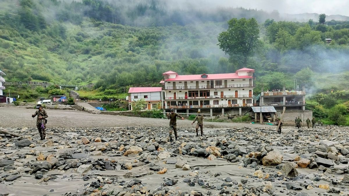
Uttarakhand has once again been struck by a disaster. At least five people died and dozens of others are missing after a cloudburst in Uttarakhand’s Uttarkashi district on Tuesday (August 5) afternoon triggered flash floods and landslides.
Swollen waters swept through the Dharali village, a tourist hotspot en route to Gangotri. A cloudburst in the Kheer Ganga river catchment area toppled houses, shops and other buildings. While rescue and relief operations continue, incessant rainfall and landslides have blocked the Gangotri Highway at several points, affecting the operations. Eleven soldiers are among the missing after a mudslide hit the Army camp in Harshil.
This is not the first natural disaster to hit Uttarkashi, which is a vulnerable zone. But why? We will explain.
Uttarkashi’s topography
Uttarkashi lies within the Garhwal Himalayas, mountain ranges dotted with unstable rock formations and rivers that are fed by glaciers.
This topography makes areas such as Dharali, Harshil, and Gangotri susceptible to landslides, flash floods, and debris flows.
The central Himalayan region has reported frequent extreme rainfall events in recent years.
According to studies by the Uttarakhand State Disaster Management Authority (USDMA), the districts of Uttarkashi, Chamoli, Rudraprayag, Bageshwar and Pithoragarh are also highly vulnerable to cloudbursts, the intensity of which has increased with a surge in temperatures in the Himalayan region.
A cloudburst is a sudden, intense downpour of rain that occurs over a small area in a short span of time, often leading to flash floods.
Quick Reads
View AllThese districts also fall in the high seismic Main Central Thrust (MCT) zone that has witnessed many earthquakes in recent years, reported Hindustan Times (HT).
“The rocks of the area are highly fragile in nature because of a number of thrusts and faults. Geomorphologically and physiographically, high relief difference, steep slopes, thick overburden and streams are common characteristics of features in the area,” Sushil Khanduri of USDMA said in a paper published in 2022 in the International Journal of Earth Sciences.
Uttarakhand has 118 high-altitude lakes, of which 32 are in Uttarkashi. “These lakes are fed by glacier melt water as maximum are located in snout areas and also receive enough precipitation during monsoon,” a study on extreme rainfall in Uttarakhand by the Department of Science and Technology in 2022 said, as per HT.
Is climate change to blame?
The impact of climate change is visible in India’s hill states, especially Uttarakhand.
Scientists warn that climate change is worsening the disasters, with glaciers in the state melting faster than ever. This is changing river flows and increasing the risks of glacial lake outburst floods (GLOFs), flash floods and landslides.
It is well-known that climate change is making extreme weather events more common and intense.
“We have seen in recent years due to climate change the intensity of extreme rainfall has increased. There has been a sudden burst of rain for 10-15 minutes due to high temperature volatility in peak tops. The frequent earthquakes loosen boulders and topsoil increasing landslides across the Himalayan belt. The gush of heavy rain brings them down along with debris from slopes at high speed causing massive devastation,” Sushil Khanduri of USDMA said.
Or is it a man-made disaster?
Unregulated construction in Uttarakhand is hurting its natural buffers that once protected the region from such disasters.
Factors such as reduced forest cover and change of moderate debris-laden slopes into near vertical slopes during road widening and constucting buildings have been blamed for extreme downpour in the hill state, as per several studies.
Unplanned construction on natural waterways of rivers and streams, including in Dharali village, has exacerbated the damage, experts say. They attribute the devastating impact of flash floods to unchecked constructions on the riverbed of Kheer Ganga, a tributary of Bhagirathi, as per HT.
The Bhagirathi Eco-Sensitive Zone (BESZ), which spans from Gaumukh to Uttarkashi, is ecologically fragile. Experts say it is necessary to underline that only climate change is not responsible for the rise in such events in Uttarakhand.
“You can see the anthropogenic signature in every such disaster. In the videos, we can see hotels, big buildings right on the river bed. The river will take its route. It is only natural to expect that it will flow freely. Any hindrances to its flow will obviously cause disasters. The massive increase in the number of landslides is again completely linked to road construction on the Char Dham route,” Mallika Bhanot, environmentalist and member of Ganga Ahvaan, a civil society collective, told the newspaper.
Locals also point out that to boost tourism revenue, authorities are allowing unsustainable development. “In the race to earn from tourism, tree felling and construction are happening at an unprecedented scale. There are no robust systems in place to manage disasters in vulnerable stretches of BESZ, despite the region having witnessed similar devastating floods in the past,” Suresh Bhai, an Uttarkashi-based environmentalist and founder of the Himalaya Bachao Andolan, told Times of India.
With inputs from agencies