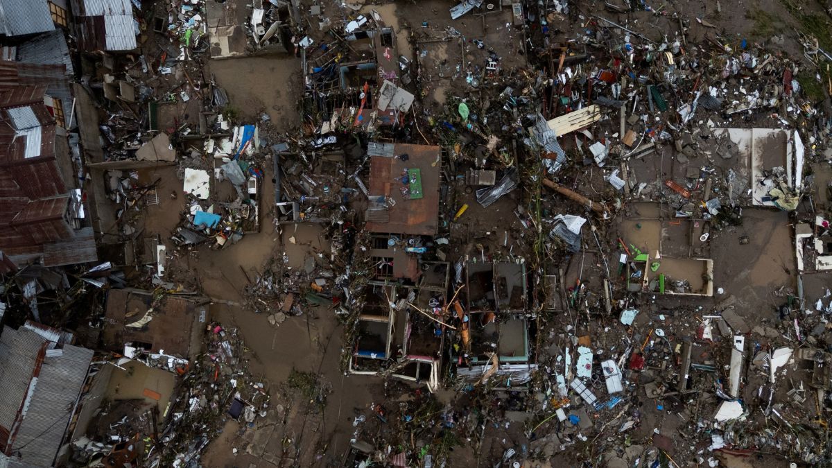
 "Drone view of wrecked homes after heavy flooding caused by Typhoon Kalmaegi in Talisay, Cebu, Philippines, November 5, 2025. File Image/Reuters")
The Philippines currently experiencing the aftermath of a major natural disaster following the impact of Typhoon Kalmaegi, which swept across the central regions earlier this week.
Government agencies have confirmed that the number of deaths has hit at least 114, and as many as 127 individuals remain missing.
Communities that directly faced the storm’s path are now coping with losses ranging from destroyed homes to disrupted livelihoods, while major rescue and cleanup operations continue under challenging circumstances.
Typhoon Kalmaegi, known locally as Tino, struck at a time when the country had already been dealing with a series of recent natural shocks.
Just over a month before this storm, a strong earthquake had hit the northern parts of Cebu province, killing several residents and displacing thousands.
The arrival of Kalmaegi added to already overwhelmed local response systems, particularly in areas where infrastructure had not yet been fully repaired after the quake.
Authorities ordered large-scale evacuations before the arrival of the typhoon, with more than 200,000 people leaving their homes for temporary shelters. However, as floodwaters receded in the hardest-hit zones, newly visible scenes of destruction confirmed the scale of the disaster.
Many households have returned to find their homes reduced to rubble, while others are contending with severe damage to property, blocked roads, and disrupted essential services such as electricity and water supply.
Impact Shorts
More ShortsThe impact extended well beyond Cebu. Regions in the Visayas and parts of Mindanao experienced widespread flooding, while southern Luzon also reported infrastructure damage and power supply disruptions.
Telecommunications in certain areas remained intermittent for days, complicating search-and-rescue missions and slowing the distribution of relief assistance.
The typhoon is continuing to move northwest over the South China Sea and is projected to intensify again as it approaches Vietnam.
Preparations are underway in several central Vietnamese provinces, where authorities have been relocating people living in vulnerable regions, warning of possible damage to agricultural lands, flash floods, and dangerous winds.
This is not the first time in recent years that Cebu and nearby provinces have experienced large-scale storm damage.
The central Philippines has been repeatedly exposed to strong weather systems, partly due to its geographic characteristics that make it vulnerable to typhoons originating over the Pacific Ocean.
How the Philippines is gearing up for another storm already
Even as emergency response teams work to manage the fallout from the storm, meteorologists in the Philippines are monitoring a newly forming system east of Mindanao.
Early projections indicate that this disturbance could strengthen, possibly reaching typhoon intensity as it moves closer to the archipelago in the days ahead.
Although it is too early to determine its precise track, the possibility of another powerful storm has raised concerns about the capacity of affected communities to withstand back-to-back climate-related events.
Such situations are far from unusual in the Philippines. On average, the country sees around 19 tropical cyclones enter its national monitoring zone each year, with between six and nine making direct landfall.
Depending on the storm’s strength, these can trigger flooding, landslides, coastal storm surges, and widespread property damage, particularly in low-lying areas or places with limited infrastructure protection.
Why the Philippines remains one of the world’s most disaster prone regions
Long before Kalmaegi struck, global disaster assessment studies had already identified the Philippines as one of the world’s most at-risk nations for natural disasters.
The country ranked first in the WorldRiskIndex 2025, a publication that assesses exposure, vulnerability, and capacity to cope among 193 United Nations member states.
The report stated, “The Philippines is once again at the top of the WorldRiskIndex this year: a country characterised by high geographic fragmentation and high exposure to weather-related extremes.”
The archipelago’s ranking is shaped by several overlapping risk factors:
A high exposure to natural hazards like typhoons, earthquakes, floods, landslides, droughts
A wide geographic fragmentation that comprises 7,641 islands, many with coastal communities
A population distribution that is high in density in low-lying and river basin areas
Infrastructure limitations that witness uneven disaster resilience capacity among regions
Climate effects that result in rising sea temperatures and changing rainfall patterns
The report also pointed out that social inequality, restricted access to healthcare, and inadequate disaster infrastructure amplify the consequences of natural events.
The Philippines is not lacking in disaster response experience, but the frequency and intensity of crises create recurring recovery cycles that stretch government resources and burden communities.
The Philippines location on the Pacific Typhoon Belt
One of the fundamental geographic explanations for the Philippines’ frequent exposure to severe storms is its position along the Pacific Typhoon Belt. This region of the ocean produces nearly one-third of the world’s tropical cyclones every year.
As these systems form and gather energy over warm waters, many ultimately move westward toward Southeast Asia, with the Philippines in a direct path.
Certain regions of the country historically face higher typhoon impacts than others. Provinces in Northern and Eastern Luzon, the Cagayan Valley region, Bicol, and Eastern Visayas often experience direct landfalls.
However, the risk extends nationwide, particularly as the country’s coastlines and river systems act as natural conduits for storm surges and flooding.
Research also shows that 60 per cent of the Philippines’ total land area and more than 70 percent of its population are exposed to disaster risk.
The primary reasons include dense settlements in flood-prone zones, settlements along fault lines, and residential development in steep mountainous terrain that is highly prone to landslides.
How climate change is increasing the severity of storms
Scientific studies indicate that while the total number of tropical cyclones globally may not necessarily increase due to climate change, the strength of the most severe storms is expected to rise.
Warmer ocean waters allow storms to gather more energy, and a warmer atmosphere holds more moisture, increasing rainfall intensity.
This means that when typhoons strike, they can produce stronger winds, more destructive rainfall, and more dangerous storm surges.
This pattern has been observed in recent years, particularly in super typhoons that have caused catastrophic impacts across the region.
The WorldRiskReport also pointed out how natural disasters can interact in complex ways with public health crises.
During the Covid-19 pandemic, for example, evacuation centres became crowded as storms struck, increasing the risk of virus transmission and complicating infection control efforts.
Why the Philippines needs to build a long-term disaster resilient model
The Philippines faces additional threats from rising sea levels. Studies warn that millions of people in Southeast Asia live in areas that could be underwater or severely inundated by the middle of the century.
Many of the Philippines’ communities are located along coastlines or small islands, making them especially vulnerable to permanent land loss.
In some regions, shoreline erosion has already forced families to relocate, and authorities have been studying long-term adaptation options such as seawalls, mangrove restoration, and managed retreat.
However, implementing these measures requires sustained funding and planning coordination across multiple government levels.
The recurring cycle of storms, earthquakes, floods, and related crises makes long-term resilience planning one of the country’s most urgent needs. Specialists point out the importance of several strategies:
Strengthening flood control infrastructure in river basins and low-lying regions
Improving urban planning to limit construction in high-risk zones
Expanding early-warning systems, especially in remote regions
Enhancing community-based evacuation and response training
Investing in healthcare and emergency service capacity to handle overlapping crises
The challenge is significant, but reducing loss of life and property requires sustained policy execution and long-term climate adaptation strategies.
Also Watch:
With inputs from agencies