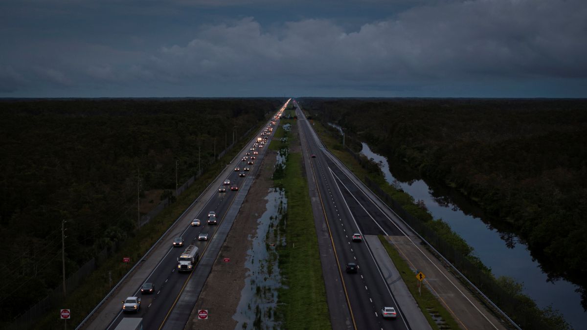
 "A drone view shows commuters driving east from the west coast ahead of the arrival of Hurricane Milton in Florida. Reuters")
More than a million residents in coastal Florida have been ordered to evacuate ahead of Category 5 Hurricane Milton. The storm threatens to hit Tampa and St Petersburg with an impact not seen in a century, bringing dangerous storm waves and turning debris from Hurricane Helene, which struck 12 days ago, into airborne hazards.
The last time a major hurricane directly struck Tampa Bay was in 1921 when the city was home to a few hundred thousand people. Today, the region has grown to over 3 million residents, making it one of the fastest-growing areas in the US and increasingly vulnerable to climate-related flooding.
Hurricane Milton , which strengthened on Monday, is following an unusual west-to-east trajectory through the Gulf of Mexico. Experts have warned that Tampa Bay’s long-standing good fortune in avoiding such storms may be coming to an end.
With sustained winds of 160 mph (260 kph), Milton poses a severe risk of storm surges exceeding 10 feet (3 metres) along Florida’s Gulf Coast. US President Joe Biden and Tampa Mayor Jane Castor have urged residents in evacuation zones to leave immediately, warning of life-threatening conditions. Although wind speeds may decrease, the storm’s size is growing, increasing the risk to more coastal communities.
Here’s what you need to know:
Why is Tampa so vulnerable?
The entire Gulf Coast of Florida is especially vulnerable to storm surge. Just last week, Hurricane Helene, which made landfall around 150 miles (240 kilometres) away from Tampa in the Florida Panhandle, still led to several deaths due to drowning in Tampa due to surges of nearly five to eight feet (1.5 to 2.5 metres) above normal tide levels.
Philip Klotzbach, a hurricane researcher at Colorado State University, told AP, “Had it made landfall just little farther to the south and east, it could have been a lot, lot worse.”
Part of the increasing danger is due to Florida’s unique coastal topography. Along the Gulf of Mexico, the coastline has a shallow, sloping continental shelf. This shallow ocean floor acts as a barrier, trapping the storm’s water and causing it to surge onto land. Meanwhile, Florida’s east coast has a much steeper ocean floor that drops off sharply just a few miles out, allowing water to flow away more easily during storms.
“You can have the same storm, the same intensity, the same everything, but very different surges,” Klotzbach said.
According to a report published in 2015 by Boston-based catastrophe modelling firm Karen Clark and Co, Tampa Bay is the most vulnerable place in the US to storm surge flooding and stands to lose $175 billion in damages.
Are residents prepared?
While Floridians are no strangers to hurricanes, Tampa has not faced a direct hit from a major storm in over a century. During this time, the region has experienced massive growth. Tens of thousands of people relocated to the area during the COVID-19 pandemic, with many choosing to live on barrier islands near Clearwater and St. Petersburg, which overlook the typically calm, emerald waters of the Gulf.
According to US Census data, more than 51,000 people moved to the area between 2022 and 2023, making it the fifth-fastest-growing metropolitan area in the country.
Long-term residents, having dealt with numerous near misses and false alarms, like Hurricane Irma in 2017, may also be unprepared for an actual direct hit. A local legend claims that blessings from the Native Americans who once occupied the region have historically shielded the area from powerful storms.
Meanwhile, MIT meteorology professor Kerry Emanuel stated that a hurricane in Tampa is the “black swan” worst-case scenario that experts have been concerned about for years. Emanuel, who has studied hurricanes for 40 years, added, “It’s a huge population. It’s very exposed, very inexperienced and that’s a losing proposition.”
“I always thought Tampa would be the city to worry about most.”
Is climate change a reason?
The impact of climate change is also a factor influencing hurricanes like Milton. Rising global temperatures, driven by greenhouse gas emissions, have led to warmer oceans, increased sea levels, and heightened moisture in the atmosphere - all of which play a crucial role in a hurricane’s intensity and the flooding it can trigger.
Angela Colbert, a scientist at NASA’s Jet Propulsion Laboratory, stated in a 2022 report that “Due to global warming, global climate models predict hurricanes will likely cause more intense rainfall and have an increased coastal flood risk due to higher storm surge caused by rising seas.”
On Monday, the National Hurricane Center in the US upgraded Milton to a Category 5 storm after it intensified by 75 mph (120 kph) within 24 hours. One contributing factor to this rapid intensification is the unusually high water temperatures, which act as fuel for the storm.
University of Miami hurricane researcher Brian McNoldy told the Associated Press “Milton’s rapid intensification is incredible.”
“I’ve been pointing out for months, the Gulf has been and is record or near-record warm,” McNoldy added.
The researcher further noted that due to rising sea levels linked to climate change, the storm surge from Hurricane Andrew would be 7 inches (17 centimetres) higher than it was when the storm struck South Florida three decades ago.
What about evacuations?
Officials began issuing evacuation orders on Monday for six counties around Tampa Bay, where nearly 4 million people live. Those residing in mobile homes, RVs, and manufactured homes - which cannot withstand winds over 110 mph (177 kph) - are particularly vulnerable.
Kevin Guthrie, Director of the Florida Division of Emergency Management, strongly requested the coastal residents to evacuate. He also noted the deaths on barrier islands during Hurricane Ian in 2022, stating that many of those deaths could have been avoided if people had crossed to the mainland and taken shelter.
“Please, if you’re in the Tampa Bay area, you need to evacuate. If they have called an evacuation order, I beg you, I implore you to evacuate. Drowning deaths due to storm surge are 100 per cent preventable if you leave,” Guthrie said.
When did a storm last hit Tampa?
Tampa has largely been spared from major storms, with most Gulf hurricanes turning north of the city. The last time the eye of a major hurricane struck the area was on October 25, 1921.
Known locally as the Tarpon Springs storm, it came ashore in the small seaside town, carrying Category 3 winds of up to 129 mph (207 kph). The storm surge reached 11 feet (3.3 metres), killing at least eight people and causing $5 million in damage, a large amount for the time.
Since then, the once quiet area has transformed into a major hub with white beaches and an economy valued at nearly $200 billion. Now, Hurricane Milton threatens to undo a century of growth and development, putting the region at risk of massive losses.
With inputs from AP