Firstpost
  • Home
  • Video Shows
    Vantage Firstpost America Firstpost Africa First Sports
  • World
    US News
  • Explainers
  • News
    India Opinion Cricket Tech Entertainment Sports Health Photostories
  • Asia Cup 2025
Apple Incorporated Modi ji Justin Trudeau Trending

Sections

  • Home
  • Live TV
  • Videos
  • Shows
  • World
  • India
  • Explainers
  • Opinion
  • Sports
  • Cricket
  • Health
  • Tech/Auto
  • Entertainment
  • Web Stories
  • Business
  • Impact Shorts

Shows

  • Vantage
  • Firstpost America
  • Firstpost Africa
  • First Sports
  • Fast and Factual
  • Between The Lines
  • Flashback
  • Live TV

Events

  • Raisina Dialogue
  • Independence Day
  • Champions Trophy
  • Delhi Elections 2025
  • Budget 2025
  • US Elections 2024
  • Firstpost Defence Summit
Trending:
  • Charlie Kirk shot dead
  • Nepal protests
  • Russia-Poland tension
  • Israeli strikes in Qatar
  • Larry Ellison
  • Apple event
  • Sunjay Kapur inheritance row
fp-logo
ISRO explains how it used the SCATSAT-1 to monitor floods across the country this monsoon
Whatsapp Facebook Twitter
Apple Incorporated Modi ji Justin Trudeau Trending

Sections

  • Home
  • Live TV
  • Videos
  • Shows
  • World
  • India
  • Explainers
  • Opinion
  • Sports
  • Cricket
  • Health
  • Tech/Auto
  • Entertainment
  • Web Stories
  • Business
  • Impact Shorts

Shows

  • Vantage
  • Firstpost America
  • Firstpost Africa
  • First Sports
  • Fast and Factual
  • Between The Lines
  • Flashback
  • Live TV

Events

  • Raisina Dialogue
  • Independence Day
  • Champions Trophy
  • Delhi Elections 2025
  • Budget 2025
  • US Elections 2024
  • Firstpost Defence Summit

ISRO explains how it used the SCATSAT-1 to monitor floods across the country this monsoon

tech2 News Staff • August 2, 2017, 10:20:15 IST
Whatsapp Facebook Twitter

ISRO used the SCATSAT-1 to track flooding across the nation during the monsoon, with a special focus on Gujarat and Rajasthan.

Advertisement
Subscribe Join Us
Choose
Firstpost on Google
Choose
Firstpost on Google
ISRO explains how it used the SCATSAT-1 to monitor floods across the country this monsoon

ISRO used the SCATSAT-1 to track flooding across the nation during the monsoon, with a special focus on Gujarat and Rajasthan. Monsoon activity in West Bengal, Uttar Pradesh, Assam and Bihar were also tracked. The satellite used data based on backscattering and brightness temperatures of the earth to monitor the flood situations. ISRO was able to capture a high resolution dataset by scanning overlapping areas with the satellite. [caption id=“attachment_3884133” align=“alignleft” width=“380”] ![Flooding in Gujarat. Image: ISRO. ](https://images.firstpost.com/wp-content/uploads/2017/08/isro-flood-inundation-problem.jpg) 
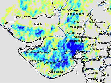
Flooding in Gujarat. Image: ISRO.[/caption] The backscattering and brightness data were combined to figure out which regions were inundated and which regions were only partially submerged. The satellite was also used to figure out the wetness of the soil in the affected areas, on how saturated or dry the regions were. Floods along the Brahmaputra and the Ganga were tracked using this method. In Gujarat, extreme floods were observed in the districts of Ahmedabad, Mehsana, Kheda, Banskantha, Bhavnagar but Bharuch was relatively dry. The INSAT-3D/3DR provides observations of cloud cover and rainfall, but is unable to image the inundation on the ground through the thick clouds during monsoons. The instruments on the SCATSAT-1 were able to penetrate the cloud cover to make the necessary observations. The data from the SCAT-SAT-1 was correlated with observations from the Sentinel-1A, which is an earth observation satellite equipped with a Synthetic-aperture radar. ISRO has provided an animation of the floods during June 2017. ![flood_as_observed_from_scatsat-1](https://images.firstpost.com/wp-content/uploads/2017/08/flood_as_observed_from_scatsat-1.gif) 
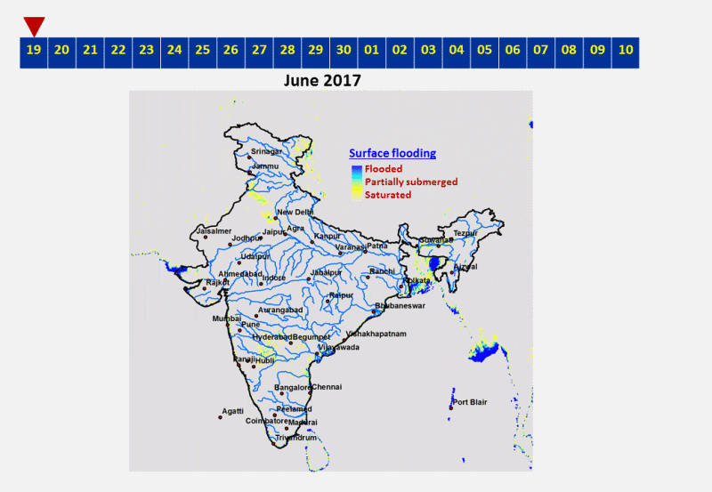
The SCATSAT-1 is an earth observation satellite that was launched on the **PSLV-C35 mission in September 2016** . The satellite gets its name from its primary payload, a Ku-band pencil-beam scatterometer. The SCATSAT-1 orbits the earth at an altitude of 720 km and provides data for detection of cyclones and weather forecasting. The SCATSAT-1 is a continuity mission to the OceanSat-2 and has a planned mission duration of five years.

Tags
ISRO ScatSat 1 pslv c35 EOS Sentinel 1A
  • Home
  • Tech
  • News & Analysis
  • ISRO explains how it used the SCATSAT-1 to monitor floods across the country this monsoon
End of Article
Latest News
Find us on YouTube
Subscribe
  • Home
  • Tech
  • News & Analysis
  • ISRO explains how it used the SCATSAT-1 to monitor floods across the country this monsoon
End of Article

Top Shows

Vantage Firstpost America Firstpost Africa First Sports
Enjoying the news?

Get the latest stories delivered straight to your inbox.

Subscribe
Latest News About Firstpost
Most Searched Categories
  • Web Stories
  • World
  • India
  • Explainers
  • Opinion
  • Sports
  • Cricket
  • Tech/Auto
  • Entertainment
  • IPL 2025
NETWORK18 SITES
  • News18
  • Money Control
  • CNBC TV18
  • Forbes India
  • Advertise with us
  • Sitemap
Firstpost Logo

is on YouTube

Subscribe Now

Copyright @ 2024. Firstpost - All Rights Reserved

About Us Contact Us Privacy Policy Cookie Policy Terms Of Use
Home Video Shorts Live TV